Friday, December 9, 2011

Saharan Dust

Saharan dust storm in 2003. We are just south of the frame of this picture
Now that we are nearing the coast of Africa, we have been seeing lots of Saharan dust coming from the continent. Why would anyone care about this dust, you might be asking? The Sahara Desert is the second largest desert in the world (Antarctica is considered the first), and is a vast dry area full of sand and dust. Strong winds often sweep over the continent from Europe, and can carry this dust thousands of miles-it can be seen across the Atlantic Ocean and into the United States. These large dust storms can carry important nutrients, as well as harmful things into the ocean and onto land, and is one of the important sources of nutrients to the ocean that is being studied on this cruise.
Aerosol samplers on the flying bridge with lots of dust!

Some scientists on board from University of Alaska, Fairbanks and from Florida State University, are studying these dust storms and other "aerosols" in the marine environment. Aerosols are tiny particles that are generally made up of some kind of dust or sea salt, and water. They are called aerosols because they are a mixture between a liquid and a solid, and are found floating in the air. Aerosols are comprised of many things, and oceanographers often distinguish between anthropogenic aerosols (aerosols that are human-derived, often forms of smoke/smog and other pollution) and natural aerosols (like those from the Sahara). By measuring the sizes of the aerosols, and the different metals and nutrients in the aerosols, scientists can often distinguish where these particles originated from and how far they have traveled. This is just what scientists on our ship have been doing everyday of the cruise since we left. They have large aerosol samplers on the "flying bridge" of the ship, which is the highest desk on the ship above everything else so that the samples don't get contaminated by any pollution coming from the ship itself.
Red/orange Sahara dust in the medium size range
Black/gray anthropogenic dust in the small size fraction
The dust from the Sahara is visibly orange/red and is generally greater than 1 micron in size. Knowing the size of the dust is helpful, because both the color and size can help scientists distinguish it from other types of dust, like anthropogenic dust, which is generally gray/black in color and in the small size range (0.45-0.95 micron). Each type of dust contains different levels of metals, and when it lands on the ocean it may have different effects on the resident phytoplankton communities.
Sahara dust on the aerosol filters

For example, dust from the Sahara usually has high levels of iron, an important nutrient for phytoplankton, so a dust storm could mean an increase in nutrients that the phytoplankton need. On the other hand, anthropogenic dust from industrialized areas has high levels of toxins such as lead and sometimes mercury, which can be potentially harmful to phytoplankton and other organisms.

Thursday, December 8, 2011

The Scientists Take Over the Galley!

Menu items
I think most people would agree that the most difficult job on the ship is the cook and the stewards (other cooks, who help with preparing meals). They have long hours, have to feed up to 60 hungry people 3 times a day, all with different likes/dislikes and diet requirements. They usually get up at 4 am each day to make breakfast, and chop and prepare other items to be used throughout the day. They stay up working until around 7pm, when they have finished cleaning all of the dishes for the day, and have planned meals for the next day. Talk about a tough job!

Melissa and Chief Scientist Greg Cutter preparing the meal
The scientists on the ship felt that the cooks had therefore been working way too hard over the past 30 days, so we asked if we could give them something in return and cook for them and all of the crew. They agreed, so a feast was prepared. The Chief Scientist, Greg Cutter, decided on making his legendary fajitas recipe, and we took the job in shifts in order to make sure we made it on time, and had enough food. Other scientists made some other delicious dishes, including homemade hummus by Chris Measures, salsa and guacamole from some of the other scientists, and desserts by Ana Aguilar-Islas and Rachel Shelley. I helped to serve the meal to all of the crew members and scientists when they came to eat.

Everyone seemed to enjoy themselves, and we definitely had a lot of fun. I think all of the cooks enjoyed the break too, and we definitely appreciate how hard they work everyday! We were in the galley (another name for the kitchen on a ship) from 10am-7pm just for one meal! It was also nice to cook a little bit for those of us who enjoy cooking, because it is usually one of the things that we miss from home when out on these cruises.

Finished product!
We are continuing on in our journey, and are almost done! We pull into port on Sunday morning in Cape Verde, and are currently on station 22 out of 24. The countdown has begun!

Thursday, December 1, 2011

Mid-Atlantic Ridge

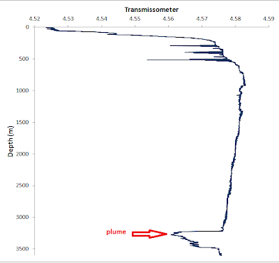
Relative amount of particles in the water over the Mid-Atlantic Ridge
We just finished a station over the Mid-Atlantic Ridge, a huge plate boundary that runs down the middle of the Atlantic ocean as a long underwater mountain range. Some parts of this mountain range are more than 3000m (about 9000 ft) higher than the surrounding ocean floor. This is only slightly lower than Mt. Whitney in California. This huge mountain range under the sea is a divergent plate boundary, or an area of the Earth's crust where two plates are moving apart from one another. In this case, the Mid-Atlantic Ridge forms the boundary between the North American Plate and the Eurasian Plate. The plates are moving apart at about 2 cm/yr. When the plates move apart, lava and other chemicals are emitted into the water that we can measure. Once the lava hits the seawater, it rapidly cools off since the seawater is colder than the lava, and looks like black smoke when it comes out of the vents. Due to this, these underwater volcanoes are often called "black smokers." Black smokers are interesting for a group of scientists studying metals, because some of these metals are emitted in extremely high concentrations near these hydrothermal vents, or underwater volcanoes. Some of the metals that were found in high concentrations at this sight were iron, and mercury. In order to sample in the plume from the ridge, we first put some sensors into the water, including one that can measure the relative amount of particles in the water at different depths. This is called a transmissometer, and where the measurements rapidly decrease (due to an increase in particles), is generally where the plume should be. We therefore collected samples in the plume, as well as directly above and below it for comparison. We also got our instrument a little too close for comfort to the bottom of the ocean at this station, and had a little bit of a scare that we might have damaged our equipment, but all was well when it came back on board (phew!).

Monday, November 28, 2011

Whales

Whale watching
Today we saw a few whales, who decided to hang out around the boat almost all day. It was a beautiful, still day, and the whales made it almost perfect. We all think it was a female Minke whale and her calf, because one was much larger than the other and they stuck very close together. They spent the entire day going back and forth under the boat, enjoying the clear blue water and investigating the sounds coming from the large pumps we had deployed over the side of the ship. Minke whales are one of the smallest whales, and they tend to be found in the open ocean rather than close to the coast. They are also baleen whales, which means they have baleen, a substance that looks and feels like hair, instead of teeth. They use this to filter phytoplankton and krill out of the water, just like in "Finding Nemo" when the whales "swallows" Dory and Marlin.
Minke whale

Next we will be heading to TAG (Trans-Atlantic Geo-traverse), a station that is directly over the Mid-Atlantic Ridge, an underwater mountain range in the middle of the Atlantic Ocean. More on this later!

Friday, November 25, 2011

Thanksgiving

Port hole decorations
Yesterday was Thanksgiving, and we all had a great day. We stopped all deck work during dinner so that everyone could sit down and enjoy the meal, because normally there is work going on non-stop so that we can make the most efficient use of our time. It was a beautiful day outside, and some of the scientists kept themselves busy by working at a leisurely pace, and others busied themselves with trying to get the best possible reception on their XM radios so they could listen to football all day.

All 3 cooks were slaving in the kitchen since breakfast, cooking 3 turkeys and 1 ham for all of us to eat, along with many other side dishes and fixings. We gave the cooks a round of applause after the meal, because they sure deserved it! Everything was delicious, and helped most of us miss home a little bit less.
Adjusting the XM radio antenna

Dinner menu and appetizers

My Thanksgiving dinner
We are moving along smoothly still with our work, and are more than half-way done now. We are now at station 13, out of 24 stations, with 20 hours of "steaming", or just driving the boat, between each station. All of us are thankful for those long steams so that we can get plenty of rest. Hopefully the rest of the cruise will remain running smoothly!

Sunday, November 20, 2011

Bermuda

Bermuda Triangle in the Atlantic
On Friday we arrived in Bermuda, a island directly east of South Carolina. Most people think of Bermuda as being in the Caribbean, but it is actually on the edge of the Sargasso Sea with the nearest land 1,000 km away. Bermuda is often also associated with historical accounts of the "Bermuda Triangle," which describes an area of the Atlantic where many ships and airplanes have been reported to go missing under "mysterious" circumstances. Modern research has revealed that there have no more disappearances in the Bermuda Triangle than in any other part of the ocean, but the name has stuck.

The pilot boat pulling up next to the R/V Knorr
Although the tales of the Bermuda Triangle are somewhat exaggerated, there are many shipwrecks along Bermuda due to the reefs that surround the island. This makes navigating the island in a boat tricky if you are not a local. To prevent an issues when a ship like ours comes in from a foreign port, it is common at all ports to have a "pilot" boat come out to meet your boat before you come into the port. This consists of a small boat coming out to meet you, pulling up alongside your boat, and the "pilot" jumps on board. The pilot is someone who has intimate knowledge of the local waters, and the pilot directs the captain as we pull up to the dock. This is especially important in Bermuda, as the harbor entrance is extremely narrow. It was hard to imagine how the huge cruise ships could fit through such a small passageway!
Pulling into the harbor at St. George's, Bermuda

Once we docked, customs came aboard to make sure everything was in order and we were allowed to go on dry land! even though we have only been at sea for 2 weeks, the prospect of going on shore was like a mini vacation. We headed directly to Tobacco Bay, a really nice beach in St. George's (one of the municipalities of Bermuda, the other one Hamilton). On our way we viewed the town, and took in the beautiful landscape. Bermuda is really colorful, owing to the crystal clear waters and the brightly painted buildings in blue, pink, green and white (these colors are mandatory in Bermuda, and are chosen based on what year the building was built). We then went to a nice dinner, and a party at the local oceanography station, called Bermuda Institute of Ocean Sciences (BIOS). Fellow collaborators at this institution put on a wonderful party for everyone on the ship, and we got to explore the station. Most people who work at BIOS live right next to the ocean science station, as the living expenses in Bermuda are really expensive, but living is subsidized on the station (the government helps pay the bills for rent so that most can afford to live there). This makes for a really fun, close-knit group of people living and working on station. 
Dinner at Wahoo's in St. George's, Bermuda

We are finishing up our work at BATS, our next station after Bermuda, and then moving on with the rest of our cruise on the way to Cape Verde. From now on the stations are much further apart (about 20 hours), so everyone is looking forward to having some nice breaks in between working hard on station!

Taking a break at Tobacco Bay, Bermuda

Thursday, November 17, 2011

Sargasso Sea

We are officially in the "Sargasso Sea" now, which is just another name for the North Atlantic gyre, or an area of the open ocean that has currents that spin around it on all sides. The North Atlantic gyre is surrounded by the Gulf Stream that runs north along the east coast of the United States, this then turns east and eventually converges with the Canary Current running south off the coast of Africa. This particular ocean gyre is called the "Sargasso Sea" because of a type of sea weed called Sargassum that accumulates there. The currents presumably cause the sea weed to collect in the gyre, and it can be seen everywhere throughout the Sargasso Sea.
Sargassum floating near our boat
We are now headed to Bermuda, and should arrive there early tomorrow morning. Everyone is busy planning what they want to do as soon as we get off the ship-most people have plans to go to the beach and go snorkeling. Then, we have a party in the evening at the BIOS station (Bermuda Institute of Ocean Sciences) where we will have some dinner with some other scientists who work there. Once we leave Bermuda on Saturday morning, our first station will be at a station that is named BATS (Bermuda Atlantic Time Series). This is a special station in the ocean because scientists go to this same exact spot in the ocean many times a year and make several different measurements each time. Thus, we have a "time series" of measurements like temperature, salinity, nutrient levels and chlorophyll levels for the past 20 years. Our data, from this cruise, can then help to decipher some of the trends perhaps that have been seen in the ocean measurements that have been previously made at this same location. Time series locations in the oceans such as BATS have been very important in helping scientists to understand how the oceans have been changing over time. Another important time series station is "HOT", or the Hawaiian Ocean Time Series. Many cruises like ours tend to overlap with these particular stations when they are in the same area, so that data can be compared between different years and different scientific groups.

Tuesday, November 15, 2011

Red Sky at Night, Sailors' Delight; Red Sky in the Morning, Sailors Take Warning

Sunset on day 3 of the cruise, before the storms began.

Sunrise before hurricane Sean.
We weathered hurricane Sean, and are now on our way to Bermuda. We are a little behind schedule though, because with the bad weather everything takes longer. When we put our instruments in the water, we have to do everything more carefully, and lower the instrument more slowly through the water since there are strong currents and winds. We also have certain "stations" (specific latitude and longitude coordinates in the ocean) where we are getting samples, but in between sampling times for different scientists the boat sometimes drifts off the station where we began, and it takes a while to drive the boat back to the original station after each scientist is taking turns gathering their samples. This has caused us some delays in the schedule, so we have canceled one of our stations before we get to Bermuda.

Besides the rough weather, we are definitely getting into much warmer waters and it is really hot and humid outside despite the wind. We have also seen a bunch of flying fish (fish that jump out of the water and glide across its surface as though they are flying), including one that almost hit me in the head when it jumped on board the ship on accident. They are attracted to the lights of the boat at night, and sometimes jump out of the water and find themselves on deck. We catch them and throw them back overboard. We also saw a huge Mahi, a really bright blue and green open ocean fish, that was circling the boat for hours last night. Many of the crew members were mad that we didn't come wake them in the middle of the night so they could try to catch it. Some of the crew are quite avid fishermen.

Friday, November 11, 2011

Cheese o'clock

Cheese platter every afternoon!
In other places of the world it might be 5 o'clock somewhere, but on a dry ship (absolutely no alcohol allowed on board) it is cheese o'clock. At 3 o'clock everyday on this boat, the cooks put out an awesome platter of cheese as a snack before dinner. I think it is the favorite time of day for most people on the ship. We even have small pagers on this ship with preset messages, so that we can get woken up or told to meet someone somewhere on the ship, and one of our preset messages is "cheese o'clock." Clearly, it is important facet of life on the boat.
Rainy night on the Knorr

Knorr in relation to hurricane Sean


We are now at station 3 and heading to station 4 at the end of the day today. We were way ahead of schedule, and now we are back on schedule because we have been delayed by a storm. Hurricane "Sean" is in the Atlantic now, but we are on the outer edge. We have gotten a lot of rain and wind, but not too big of swells. We have continued work on normal, but everything takes longer because of the weather. The storm is supposed to pass us in the next 36 hours and then we can continue on our way to Bermuda!

Tuesday, November 8, 2011

It's My Job

Some of the Woods Hole Scientists waving goodbye as we pull away from the dock
We shoved off on Sunday from Woods Hole, with a few of the Woods Hole faculty members there to wish us well and wave goodbye. There was hardly a breath of wind, and the sun was out. We couldn’t have asked for much better weather. On Sunday we did a bunch of safety drills, which included putting on our survival suits, also known as “Gumby suits” because you look like Gumby when you put them on. They are huge wetsuit-like suits that cover your head as well, and have lights and reflectors on them. Everyone on the ship has one in case of an emergency. Usually the only people who have to put these on at beginning of the cruise are the people who are sailing on a ship for the first time, but the captain made all of us put them on. I should have had my camera for that, because it was quite a sight to see 32 Gumbies walking around.
Deploying the GEOTRACES rosette of sampling bottles over the side of the ship.
Inside our make-shift lab, also called the "bubble" because it is made of walls out of plastic to protect from the metal ship.
We got to our first station in the evening, and stayed up all night collecting water samples, and filtering them. My job on this cruise, involves getting everyone on the ship’s sampling bottles ready before we put our sampling instrument into the water. The instrument we use has 24 12 liter bottles attached to it, along with some other instruments. We send it over the side of the ship on a wire, and then we close each bottle, at which ever depth we would like to collect water from, by clicking a button the computer on the ship. Then we have 12 liters of water from 12 different depths, because we usually close 2 bottles at each depth. At each station, we do this twice, so that at any given spot in the ocean where we stop the ship and gather water, we will have samples from 24 different depths going from the surface all the way down to the bottom of the ocean (usually about 3000-5000m). This is a big job. To do this, we first gather everyone’s bottles and put them in separate crates corresponding to which depth they would like a sample from. This makes it easy for us when we are filling up the bottles, so that we can just take one crate at a time. Once we have all the bottles ready in the crates, then we are ready to deploy our instrument over the side of the ship. This takes 4 people to do. One person operates the winch, which is a big crane that can support the weight of the instrument. One person gives hand signals to the person operating the big crane, and the other 2 people operate “tag lines” which are ropes attached to the instrument so that the instrument doesn’t swing when we raise it and put it over the side of the ship. The instrument then goes down in the water to all of the depths we want to sample, then we bring it back up on the deck. We take the bottles into a large “van” that is on the deck of the ship, which is a make-shift lab made out of a large shipping container. Since we are sampling for metals, this protects the water from getting any contamination from the ship, since the ship is a huge hunk of metal. Then we fill up all the bottles for everyone on the ship who wants a sample, and then distribute them and put them away. Some scientists on board are analyzing the samples right away, and others are taking them back to their lab to analyze at home. The whole process takes about 8-10 to complete, then we go to sleep and do it again!

Saturday, November 5, 2011

Planes, shuttles, buses, subways, and now a boat.

Pond near Boston Common

Back-up on the assembly line loading the food  

The R/V Knorr getting ready for the cruise
This week I arrived in Boston, MA before heading to Woods Hole to leave on the cruise. I stayed in Boston for the night and got to see Fenway Park, and almost the whole city. I did the Freedom Trail, and relaxed a bit in Boston Common. After my visit in Boston, I took the subway to the bus station, then the bus for two hours to Falmouth, then I smuggled myself on a shuttle to the ferry dock in Woods Hole headed to Martha's Vineyard, and finally I walked to the dock where we were loading our boat, the R/V Knorr. Everyone has now been busy this week loading the scientific equipment we need for our research, as well as securing things around the ship- tying everything down to make sure it doesn't fly about the boat when we go out to sea and start moving a lot with the swells. The Knorr is a large ship, about 200 feet long, and there are a lot of things to take care of before leaving. The crew has to make sure everything on the boat is in working order, the scientists have to set-up and test their equipment, and the most important part is the food we will need on our 36 day cruise has to be loaded. This is a huge job, and one that involved almost everyone who is going on the boat. We all make a huge assembly line from the dock to the kitchen, and pass the food along to each person, and finally to the cook, who places in the pantry and freezers. I have never seen as much food as was loaded onto the boat this time- it took almost 3 hours! This is because our final stop is in Cape Verde, which are small islands and do not have a lot of grocery stores for the cook to buy more supplies before turning around and heading back to Woods Hole. We are leaving tomorrow morning, so the final preparations are being made today and then we are off!

Tuesday, October 18, 2011

GEOTRACES: Atlantic

Cruise Track for GEOTRACES cruise 2011
I'm getting ready to embark on my next "cruise", though not to type where you play shuffle board and sip fancy drinks with little umbrellas. This "cruise", or perhaps more properly named a "voyage", is an oceanographic research cruise with the purpose of studying the chemistry of the ocean. Specifically, the scientists on board this research vessel (the R/V Knorr) will be studying different metals in ocean. Most of the time we think of metals as the stuff that makes up things we see everyday: aluminum cans, steel or iron ore beams for buildings, or gold in jewelry. All of these metals come from rocks in the Earth, and these rocks also influence what types of metals, and minerals that are in our oceans. These metals are important to study because some of them are important nutrients for organisms in the oceans (just like we need iron, they need iron too!), some are toxic (animals don't want to eat some arsenic either...), and some help oceanographers to understand how the currents and different water masses move around the globe. I am studying iron and copper, and both are important metals that effect the growth of tiny plant-like animals that live in the sea, called phytoplankton. These little plants (I do mean little, you can't see them with the naked eye) have a BIG impact on our climate, even though they are so small. Just like trees on land, phytoplankton do photosynthesis in the ocean, which means they take in carbon dioxide and produce oxygen. This is essential not only for the other sea creatures living in the ocean, but also for us. Phytoplankton in the ocean produce half of the oxygen that exists in the air that we breathe! They also take up carbon dioxide in the process, and therefore help to reduce the amount of this greenhouse gas in our atmosphere. Important little guys!

Our cruise will cross the North Atlantic Ocean, deploying instruments and collecting samples to study the metals that effect the growth of phytoplankton. This cruise is important because it is just one cruise out of many, in a project called GEOTRACES, that is seeking to measure these metals in every ocean of the world. This is the first time EVER that this has been done. Pretty remarkable considering how much we know about the moon, and how relatively little we know about the oceans.